Geothermal District Heating in Europe

GEOTHERMAL DISTRICT HEATING IN EUROPEGeothermal district heating

Where?
France
What?
Geothermal District Heating
When?
2021

THE PROJECT

One of Europe’s leading geothermal developers is exploring the potential of a poorly developed geothermal reservoir that is also targeted for public water supply in France. The context is not dissimilar to the Yarragadee aquifer in Perth which is used to provide 25% of the public water supply and is also targeted by 26 geothermal and injection wells.

For more info about this or similar projects
Talk to us today

OUR ROLE

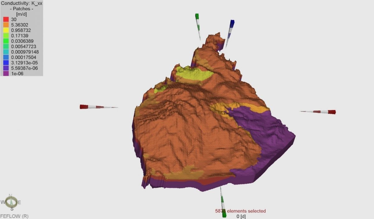
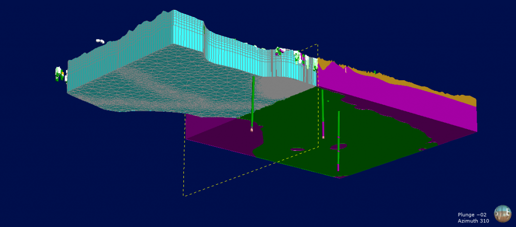
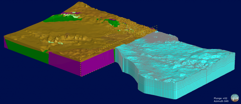
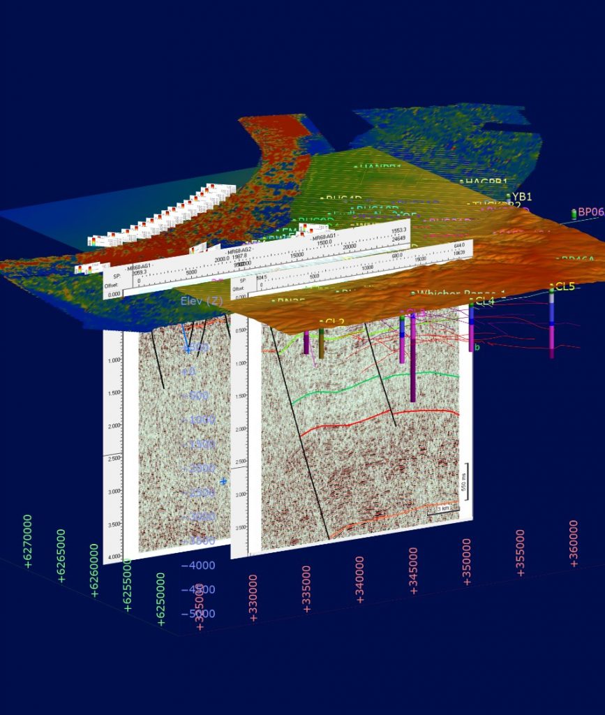
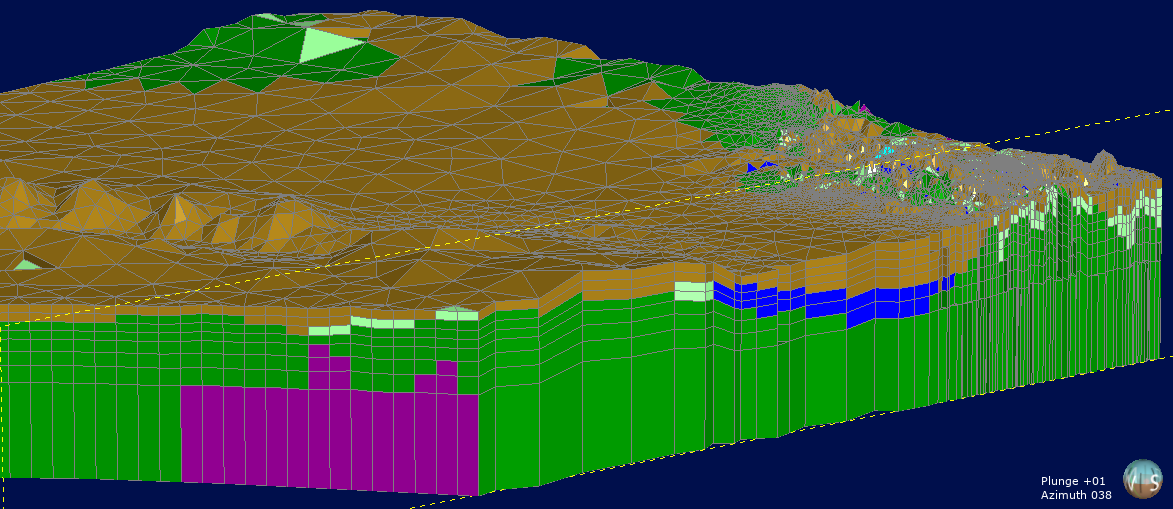
To assess the impact of injection of geothermally cooled water on the aquifer, Rockwater constructed a comprehensive geological model of the target aquifer in France. The geological model incorporated a major fault displacing the porous sandstone intervals.

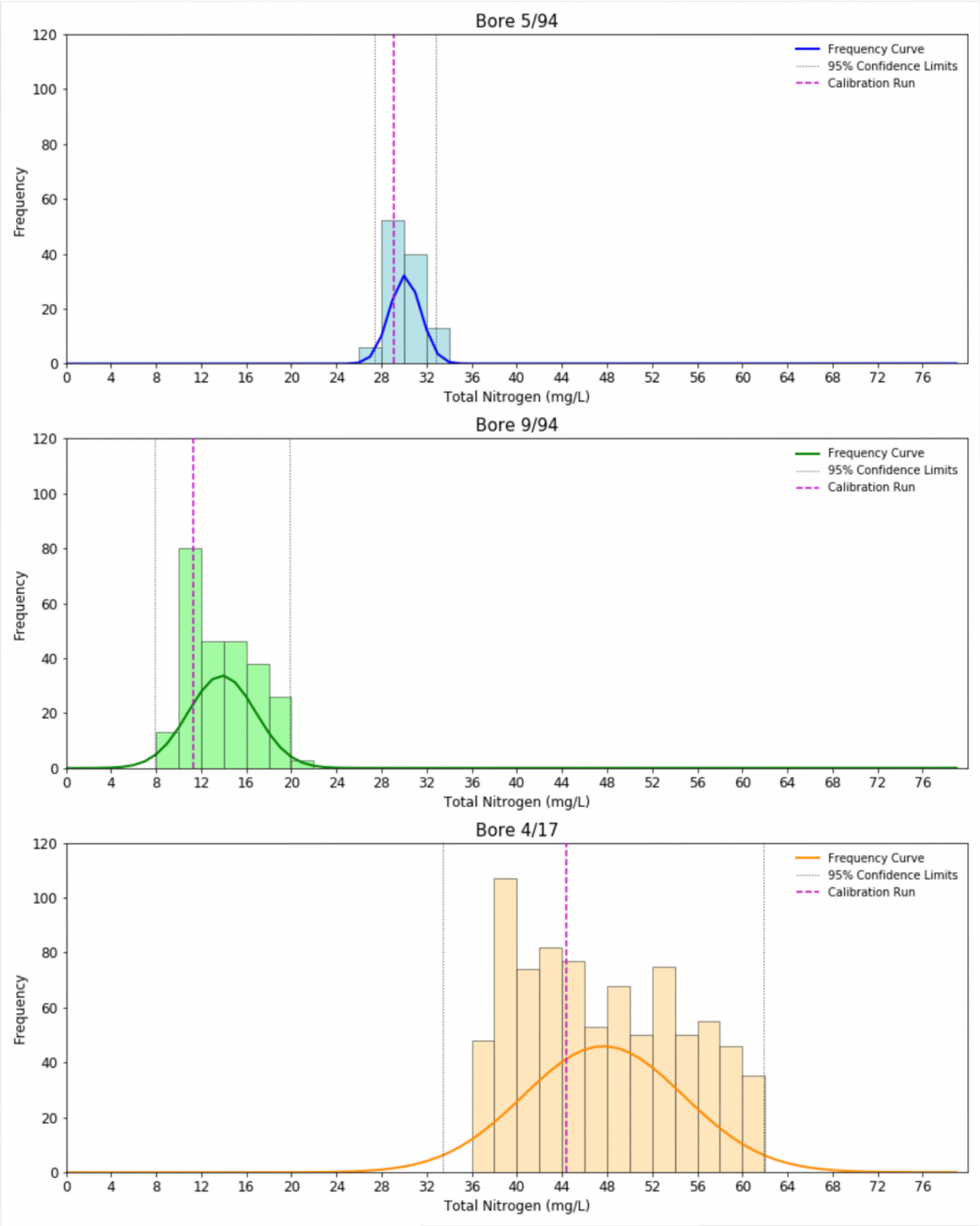
Numerical groundwater flow and heat transport modelling was used to estimate the likely impact of injection on nearby production bores used for potable water supply. To provide a probabilistic the numerical model was run multiple time using a Monte-Carlo approach.

Another aspect of the study included geochemical modelling using the PHREEQC code of precipitation/dissolution reactions caused by the cooling of the geothermal water down to very low temperatures after circulation through a heat pump.

The Rockwater study was used to estimate the optimum injection temperature and ensure no detrimental impact on the nearby bores used for water supply. The study was completed in line with the local regulatory framework and produced in French to be included in a public tender.

Rockwater is leading in geothermal modelling.

ANALYSIS AND REPORTING
  • Geothermal modelling study
  • Geochemical modelling study
  • Monte-Carlo predictive uncertainty analyses
FIELD METHODS
  • Leapfrog Geo
  • PHREEQC modelling
  • Geothermal modelling

Similar Projects

Electricity Generation for Green Ammonia

Montgomery House

Latrobe City Council

Pawsey Supercomputer

More photos

Want to know more?

ENQUIRE FOR MORE INFO NOW
Read more

Electricity Generation for Green Ammonia

ELECTRICITY GENERATION FOR GREEN AMMONIADeveloping geothermal resources

Where?
Western Australia
What?
Geothermal Electricity Generation
When?
2021

THE PROJECT

One of Australia’s largest companies is actively exploring the potential for green ammonia production in Western Australia. Geothermal electricity generation from onshore hot sedimentary aquifers is attractive because geothermal energy is available 24/7 unlike other renewables. It can also provide desalinated water using waste-heat from the geothermal process.

For more info about this or similar projects
Talk to us today

OUR ROLE

Rockwater used its proprietary code PyGeo to conduct a basin-wide analysis of the Levelised Cost of Electricity (LCOE) of geothermal electricity generation in one of Western Australia’s foremost onshore sedimentary basin.

Unlike simple temperature mapping analyses, the code combined temperature information with Monte-Carlo porosity and permeability values to produce probabilistic estimates of the achievable geothermal power versus depth.

The results of the basin-wide assessment were used to identify sub-areas within the basin with high potential. For these areas, the PyGeo code used reservoir specific porosity and permeability trends combined with seismic horizon grids and temperature grids to generate spatial LCOE maps.

The Rockwater workflow was highly successful and contributed to the identification of two areas with a 20 MW+ potential and competitive LCOE.

Rockwater is the leader in developing geothermal resources in Australia.

ANALYSIS AND REPORTING
  • Geothermal feasibility study
  • Financial modelling (LCOE, IRR, NPV)
FIELD METHODS
  • Python scripts
  • Leapfrog Geo
  • Seismic interpretation (DUG Insight)

Similar Projects

Montgomery House

Latrobe City Council

Pawsey Supercomputer

Scarborough Beach Pool

More photos

Want to know more?

ENQUIRE FOR MORE INFO NOW
Read more

Thunderbird Dewatering & Water Supply

THUNDERBIRD DEWATERING & WATER SUPPLYModelling of flow in a sedimentary basin

Where?
Kimberley, Western Australia
What?
Modelling of flow in a sedimentary basin
When?
2016-20

THE PROJECT

Sheffield Resources is developing the Thunderbird Mineral Sands Project in the Dampier Peninsula of the Kimberley.  The project is targeting a large heavy mineral sands resource, with a mine life of up to 45 years.

Competition for groundwater resources and the large scale of the project required a robust groundwater model encompassing a large part of the Dampier Peninsula.

For more info about this or similar projects
Talk to us today

OUR ROLE

Rockwater developed a conceptual hydrogeological model for the Dampier Peninsula and used it to construct a FEFLOW model.  This code allowed model-refinement in areas of interest, running of statistically-valid climate change scenarios, PEST sensitivity analyses, and predictive uncertainty assessments.

An H3 Level of Hydrogeological Assessment with the modelling results was prepared by Rockwater to support an application for an allocation of 13 GL/annum.

ANALYSIS AND REPORTING
  • Flow modelling in FEFLOW
  • Predictive uncertainty analysis using PEST
  • Annual compliance reporting
FIELD METHODS
  • Water level monitoring
  • Water quality sampling
  • Geophysical logging
  • Pumping tests

Similar Projects

Woodie Woodie Dewatering – Modelling

Geraldton Waste-Water Reuse

Busselton Salt Water Intrusion

Southdown Mine Water Supply

More photos

Want to know more?

ENQUIRE FOR MORE INFO NOW
Read more

Woodie Woodie Dewatering – Modelling

WOODIE WOODIE DEWATERINGModelling of flow in fractured rock

Where?
East Pilbara, Western Australia
What?
Modelling of flow in fractured rock
When?
Since 2011

THE PROJECT

Woodie Woodie, operated by Consolidated Minerals, is one of Australia’s largest suppliers of high-grade manganese ore.

With a historical dewatering rate of 250–2,000 L/s, Woodie Woodie is also one of the top ten dewatering operations in the world, by historical pumping volume.

For more info about this or similar projects
Talk to us today

OUR ROLE

Rockwater developed and maintains an eight-layer FEFLOW model to simulate drawdowns around pit sumps and production bores with extraction rates of up to 150 L/s.  The client’s regional Leapfrog geological model, geophysical datasets and historical water level and pumping data, were used to define high-permeability faults and low-permeability barriers, which dominate groundwater flow in the mine corridor.

The FEFLOW model is also used to assess environmental impacts on stygofauna and other environmental receptors in the region.

ANALYSIS AND REPORTING
  • Geological and geophysical interpretation
  • Leapfrog model evaluation to a finite element grid
  • FEFLOW flow modelling
  • Predictive uncertainty analysis
  • Annual compliance reporting
FIELD METHODS
  • Packer testing
  • RC exploration drilling
  • Dual-rotary and dual tube flooded RC holes
  • Pumping tests

Similar Projects

Geraldton Waste-Water Reuse

Busselton Salt Water Intrusion

Southdown Mine Water Supply

More photos

Want to know more?

ENQUIRE FOR MORE INFO NOW
Read more

Geraldton Waste-Water Reuse

GERALDTON WASTE-WATER REUSEModelling of flow and nutrients

Where?
Geraldton, WA
What?
Modelling of flow and nutrients
When?
2019

THE PROJECT

The Geraldton No.2 Wastewater Treatment Plant is licensed to treat up to 3.5 ML/d of waste-water.

In 2015-17, about 1.9 ML/d were being treated and infiltrated to the Tamala Limestone, part of the Surficial Aquifer.  Up to 900 KL/d of the infiltrated wastewater were extracted by bore A1-97 and used to supply third-parties with water for irrigation.

For more info about this or similar projects
Talk to us today

OUR ROLE

As part of the Nutrient Management Strategy for the project, Rockwater was engaged by the Water Corporation to model the extent to which nutrients are being naturally removed between the WWTP and the extraction bore.  The flow and solute-transport applications of MODLOW were used.

Using Python scripts in FloPy, the model was run 1,000 times under various combinations of input parameters to analyse the uncertainty of the water level and nutrient concentration predictions.

ANALYSIS AND REPORTING
  • Flow modelling in MODFLOW
  • Solute transport modelling in MT3D
  • Predictive uncertainty analysis in MODLFOW run by FloPy
FIELD METHODS
  • Water level monitoring
  • Water quality sampling

Similar Projects

Busselton Salt Water Intrusion

Southdown Mine Water Supply

More photos

Want to know more?

ENQUIRE FOR MORE INFO NOW
Read more

Busselton Salt Water Intrusion

BUSSELTON SALT WATER INTRUSIONModelling of flow and density (salinity)

Where?
Busselton, Southern Perth Basin, Western Australia
What?
Modelling of flow and density (salinity)
When?
2017-19

THE PROJECT

Busselton Water provides high-quality drinking water to the City of Busselton and surrounding areas.  The supplies are primarily obtained from production bores constructed within the Yarragadee Aquifer.

For more info about this or similar projects
Talk to us today

OUR ROLE

In 2017-19, Rockwater conducted a 3D modelling investigation to predict the inland migration of coastal saline water into the Yarragadee Aquifer under various scenarios of borefield extraction.

The framework for the model was established by combining geological and geophysical datasets in Leapfrog and importing them into FEFLOW.  The model was successfully calibrated for flow and density under steady-state and transient conditions with the aid of Python scripts, and is being used by Busselton Water to inform their 2020-2050 Water Management Plan.

For the last 40 years, Rockwater has worked to ensure that a consistent supply of potable water is available for the City of Busselton. We have assisted with bore design, construction, testing and maintenance involving re-ling of corroded casings.  We continue with this work and provide regular regulatory reporting.

ANALYSIS AND REPORTING
  • Geological and geophysical interpretation
  • Geological modelling in Leapfrog
  • Flow modelling in FEFLOW
  • Density modelling in FEFLOLW
  • 30-year Management Plan
FIELD METHODS
  • Down-hole geophysical surveys
  • Artesian flow logs
  • Airborne EM surveys
  • Seismic surveys
  • Packer-tests
  • Mud-rotary bores
  • Down-hole CCTV and Televiewer surveys
  • Pumping tests
  • Artesian flow tests

Similar Projects

Southdown Mine Water Supply

More photos

Want to know more?

ENQUIRE FOR MORE INFO NOW
Read more

Southdown Mine Water Supply

SOUTHDOWN MINE WATER SUPPLYModelling of flow in a sedimentary basin

Where?
South Coast, Western Australia
What?
Modelling of flow in a sedimentary basin
When?
2017

THE PROJECT

The Southdown Joint Venture is planning to mine the Southdown magnetite deposit, located nearby to Wellstead, about 90 km north-east of Albany. The total mineral resource at Southdown is currently 1.25 Bt at 33.7 % Davis Tube Recovery.

At a mining rate of 5 Mtpa, it is estimated that up to 120 L/s of saline water will be required during the mine construction phase, and that up 110 L/s of fresh water will be required for ore processing and the operation of a slurry pipeline to Albany during the mine operation phase.

The main options for obtaining the water are a desalination plant at Cape Riche and/or sedimentary aquifers within sub-basins of the Bremer Basin between Albany and Wellstead.

For more info about this or similar projects
Talk to us today

OUR ROLE

The results of exploration drilling conducted by Rockwater revealed the presence of a large sub-basin (of the Bremer Basin) centred on Wellstead.  Two deep, saline, confined aquifers were identified within the Werillup Formation at the base of the Wellstead sun-basin, which were subsequently evaluated by the drilling and testing of several production bores.

A five-layer MODFLOW model was developed based on the results the exploration, and production bore drilling and testing programmes.  Calibration of the model was performed in  steady-state, mostly using water levels in the overlying Pallinup Formation, which is widely used for stock-water supply.

Transient runs of the model indicated that the confined Werillup aquifers should be able to supply the 120 L/s of saline water needed for the mine construction phase, without significantly affecting water levels in the Pallinup Formation (water table aquifer).

Rockwater became involved with the Southdown project in 2006.  Since then, we have also delineated sub-basins at Sunday Swamp and Redmond-King River, and established a fresh-water borefield at Redmond-King River.

ANALYSIS AND REPORTING
  • Flow modelling in MODFLOW
  • Drilling, testing and modelling reports
FIELD METHODS
  • Gravity surveys
  • Air-core exploration drilling
  • Mud-rotary production bores
  • Down-hole geophysical logging
  • Pumping tests
  • Water quality sampling

Similar Projects

More photos

Want to know more?

ENQUIRE FOR MORE INFO NOW
Read more